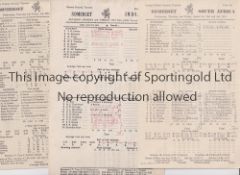
• Home
  • Search Results

958 item(s)

Refine your search

Estimate

Filter by Price Range

Location

Category

  • Maps (958)
Remove filter

Creator / Brand

Item Type

Auction Type

Country

Auctioneer

Filtered by:

  • Category
  • List
  • Grid
  • 958 item(s)
    /page

SOMERSET C.C.C. Over 110 home and away scorecards, 82 from the 1950's including v Australia 1953 and 1956, Pakistan 1954, India 1959, West I...

FRANK WORTHINGTON Autographed 12 x 8 col photo of Worthington in full length action for the Tampa Bay Rowdies, c1981, signed All The Best in ...

Collection of Ordnance Survey maps, GNER china and railwayana, glasswares including decanter, part tea sets, decorative porcelain, etc.

A group of bathymetrical surveys of the Freshwater Lochs of Scotland, published by the Royal Geographical Society. (1 box)

A 17th century hand-coloured and engraved map of Northumberland by Robert Morden, 43cm x 36cm, together with a further Robert Morden map of the Bi...

An early 17th-century Dutch hand-coloured and engraved map of Northumberland, Cumbria and Durham, published Amsterdam 1607, 14cm x 19cm, together ...

After George Taylor (1760 - 1788) The Road from Elvanfoot to Dumfries Antique hand-coloured plate map, to reverse 'The Road from Glasgow to Longto...

Edward Stanford, City of Victoria Vancouver Island water-colour tinted engraved map, dissected and laid of cotton, cloth covered boards with prin...

Pieter van den Keere for John Speed, three hand coloured engraved miniature maps from Speed’s Epitome; to include; Tartaria, China & The Turkish E...

Warwickshire, three antique framed maps of Warwickshire, including; Bowen & Owen Warwickshire, Warwickshire by Christopher Saxton from Camden’s Br...

W Peacock Superior Dissected Map of England and Wales in pictorial wooden box: The map is Gall & Inglis' England and Wales, which is colored by co...

Select Views in the County of Lincoln engraved by Bartholomew Howlett. [Printed by W. Bulmer & Co, London, 1802]. XIII, XIV & three others. (5)

An early 19th century engraved and hand coloured map of Newcastle upon Tyne & Gateshead, published 1808, 18 cm x 23 cm together with three later m...

HARRY MARGARY & PHILLIMORE CO LTD '250 YEARS OF MAP MAKING' county of Sussex, complete and Great Wishford ordnance survey maps, 1941

EMAN. BOWEN: ACCURATE MAP OF DEVONSHIRE divided into Hundreds (rolled, torn), and a collection of various unframed maps, including Dorset maps, on...

EMAN. BOWEN: 'AN ACCURATE MAP OF THE COUNTY OF SURREY' coloured, with C.Smith, 'A New Map of the County of Surrey', both framed (2) (some damage a...

A COLLECTION OF PRINTS, ETCHING AND MAPS

Lot 652

ANTHONY BROWN

ANTHONY BROWN Kimmeridge, collage, 55 x 42cm, with Bunty Mabley, Standing Stones and other collages, and a print of City of London School and two ...

JEFF SUDDERS: 'A PERFECT EVENING (WINDERMERE)' colour prints, framed as a tryptych, signed to the margin, and a further collection of pictures, pr...

Collection of various military maps together with an early copy of the Daily Mail from 1896 (1 box).

Map. Joan Blaeu - Northamptonshire, double page engraving 1645 or later, hand coloured, 41 x 50.5, two others Buckinghamshire and Nottinghamshire...

Map.  John Speed Suffolk, double page engraving 1876, handcoloured, 38 x 51cm, birds eye maple frame Close mounted, condition very good

Map. Joan Blaeu (1596-1673) - Comitatus Northumbria, Vernacule Northumberland, double-page map, s.n., s.l., n.d. [17th c], engravings, the hand-co...

WW2 British Escape and Evasion Silk Map Sheet 43E / 43F. Double sided in colour covering Germany and central Europe on one side and Croatia and th...

1970s London Underground map poster

ENGLAND 1966 TRAINING TOP (XL)

LATE 18th CENTURY PRINTED AND HAND-COLOURED PAPER AND HARDWOOD JIGSAW PUZZLE OF THE WORLD IN TWO LINKED CIRCLES, entitled to label on slide-top bo...

QUANTITY OF LOCAL MAPS

Various antique collecting books, comprising Miller's Antiques Guides for 2005, 1998, Miller's Understanding Antiques, Laver (James) Costume, Tool...

R.F. King (20thC). Lincoln Cathedral, artist signed coloured etching, 30cm x 19.5cm, framed map Lincolnshire, and framed photograph Lincoln Steep ...

A CARVED WOODEN BOX rectangular, the hinged cover and sides with carved decoration, the interior lined with maps of areas of Scotland. 28.5cm by 2...

A GEORGE III MAP SAMPLER, 1786, worked in coloured silks on a loosely woven ground with a map of England and Wales by Sarah Rushton of Macc(lesfie...

A LARGE TRAY OF BRITISH POSTCARDS, sorted by country / area, with many vintage examples, postcards contain views of churches, monuments, parks, st...

JOHN OGILBY. The Road from Glocester to Montgomery; The Road from London to Okeham; engraved road strip maps, coloured, Pl. 13 x 18 in, a pair: an...

JOHN SPEED. Engraved map of Herefordshire; an engraved map by John Speed titled 'Worcestershire Described' and a further map by John Speed titled ...

JOHN SPEED. An engraved map of Rutlandshire with Oakham and Stanford...', coloured, published by John Sudbury and George Humbell ' in Pope's Alley...

JOHN SPEED. Engraved map of the Isle of Wight, sold by Thomas Basket in Fleet Street and Richard Chiswell in St Paul's Churchyard, hand coloured, ...

An engaved map of Northern Ireland, hand coloured , with printed inscription top left' Miliaria Irlandica Com', Pl.13 x 19 in

HENRICUS HONDIUS. An engraved map of East Ulster, hand coloured with printed title 'Vltoniae Orientalis Pars', Pl.13 1/2 x 15 in

Twenty six Second World War G.S.G.S maps with 3 reference cards - black nos. 4, 7, 7, 8, 13, 14, 15, 16, 20, 21, 22, 3a & 8, 7a & 13a, red nos. 6e...

A vintage Historical Map of England and Wales, and another of Scotland, published by John Bartholomew & Son Ltd, Edinburgh, both framed, 67 x 99cm

vintage Chesterman Sheffield survey 66ft measuring chain

Spanish 'piece of eight' 8 reale coin, recovered from the site of the wreck of HMS Association on Gilstone Ledges, Isles of Scilly

AN ISLE OF MAN GOLD 1/10 ANGEL, 2014.

A quantity of vintage maps to include Bartholomew hessian-backed maps of the UK Location: RAB If there is no condition report shown, please reques...

A MINIATURE GLOBE ON A STAND. 37cms high.

Loading...Loading...

Recently Viewed Lots