Filtered by:
- Sale Section
- List
- Grid
A subscription to the Price Guide is required to view results for auctions ten days or older. Click here for more information


Africa. Blaeu (Willem Janszoon), Africae nova descriptio. auct: Guiljelmo Blaeuw. Amsterdam, circa 1640, engraved carte-a-figure map with contempo...

Asia. Coronelli (Vincenzo Maria), Asia Divisa nelle sue Parti secondo lo stato presente.., 1690
Asia. Coronelli (Vincenzo Maria), Asia Divisa nelle sue Parti secondo lo stato presente.., Venice, circa 1690, hand-coloured engraved map on two c...
![Asia. Mercator (Gerard & Hondius Jodocus), Asia ex magna orbis Terre..., [1604 or later]](https://portal-images.azureedge.net/auctions-2023/srdom10213/images/9c0ad5e6-e964-44a5-ab68-afcf00c97d19.jpg?w=155&h=155)
Asia. Mercator (Gerard), Asia ex Magna Orbis Terre Descriptione Gerardi Mercatoris Desumpta, Studio et Industria G.M. Iunioris [1604 or later], en...
![Asia. Ortelius (Abraham), Asiae Nova Descriptio, Antwerp, [1575 or later]](https://portal-images.azureedge.net/auctions-2023/srdom10213/images/68728298-f98e-4a13-9816-afcf00c97dd2.jpg?w=155&h=155)
Asia. Ortelius (Abraham), Asiae Nova Descriptio, [1575 or later], engraved map with contemporary outline colouring, large strapwork cartouche, la...

Asia. Van den Keere (Pieter), Asiae Nova Descriptio Auctore..., Amsterdam, 1614, uncoloured engraved carte-a-figure map with costumed figures to t...
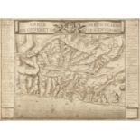
![Badeslade (Thomas & William Henry Toms). [Chorographiae Britanniae], 1741](https://portal-images.azureedge.net/auctions-2023/srdom10213/images/1e286a4a-f73f-4105-8c6b-afcf00c97f47.jpg?w=155&h=155)
Badeslade (Thomas & William Henry Toms). [Chorographia Britanniae. Or a set of Maps of all the Counties in England and Wales, London, 1741], lacki...

* British County Maps. A Collection of 40 maps, 17th - 19th century, including Valk (G. & Schenk P.). Glocestria Ducatus cum Monumethensi Comitatu...

British Isles. A collection of 18 maps, 17th - 19th century, engraved maps, including examples by or after Van der Aa, Magini, Giustiniani, Mallet...
![British Isles. Blaeu (Johannes), Insulae Albion et Hibernia..., [1654]](https://portal-images.azureedge.net/auctions-2023/srdom10213/images/a7bd2187-7162-4366-9758-afcf00c9812a.jpg?w=155&h=155)
British Isles. Blaeu (Johannes), Insulae Albion et Hibernia cum minoribus adjacentibus [1654], engraved map of the British Isles on a Ptolemaic pr...

British Isles. De Fer (Nicolas), Les Isles Britanniques ou se Trouvent Les Royaumes D'Angleterre, D'Ecosse et D'Irlande, Paris, 1706, hand-coloure...
![British Isles. Hole (G.), Britannia [1637]](https://portal-images.azureedge.net/auctions-2023/srdom10213/images/9cf502b3-3966-4620-acb0-afcf00c9825b.jpg?w=155&h=155)
British Isles. Hole (G.), Britannia [1637], hand-coloured engraved map displayed in an oval cartouche with decorative margins, trimmed to the neat...

British Isles. Lotter (Tobias Conrad), Le Grande Bretagne ou Les Royaumes D'Angleterre et D'Ecosse comme aussi le Royaume D'Irlande Divisée par Pr...
![British Isles. Muster (Sebastian). Tabula Britanniae [1578 but a 1621 edition]](https://portal-images.azureedge.net/auctions-2023/srdom10213/images/797ab8e1-17f6-4847-bf89-afcf00c983a0.jpg?w=155&h=155)
British Isles. Muster (Sebastian). Tabula Britanniae, Basle [1578 but a 1621 edition], an uncoloured woodblock 'Ptolemaic' map on a trapezoidal pr...

Camden (William). Britannia or a Chorographical Description of Great Britain..., 2 volumes, 1753
Camden (William). Britannia or a Chorographical Description of Great Britain and Ireland, together with the Adjacent Islands..., Revised, Digested...

Chatelain (Henry Abraham). Nouvelle Carte d'Angleterre, d'Ecosse, et d'Irlande..., circa 1719
* Chatelain (Henry Abraham). Nouvelle Carte d'Angleterre, d'Ecosse, et d'Irlande, avec des Instructions pour Connoitre les Differents Etats de la ...

China. D'Anville (Jean Baptiste Bourguignon), Carte la plus Generale et qui Comprend La Chine, La Tartarie Chinoise et le Tibet Dressée sur leas c...
![China. De Jode (Cornelis), China Regnum, Antwerp [1593]](https://portal-images.azureedge.net/auctions-2023/srdom10213/images/46ab2b32-35e1-4c57-af6a-afcf00c985fb.jpg?w=155&h=155)
China. De Jode (Cornelis), China Regnum, Antwerp [1593], uncoloured circular engraved map with an ornate foliate strapwork border with a roundel t...

China. Jansson (Jan), China Veteribus Sinarum Regio nunc Incolis Tame dicta, Amsterdam, circa 1636
China. Jansson (Jan), China Veteribus Sinarum Regio nunc Incolis Tame dicta, Amsterdam, circa 1636, engraved map with contemporary outline colouri...
![China. Mercator (Gerard), China, [1606 or later]](https://portal-images.azureedge.net/auctions-2023/srdom10213/images/a0365af0-a3f0-4371-aa1a-afcf00c9874e.jpg?w=155&h=155)
China. Mercator (Gerard), China, [1606 or later], hand-coloured engraved map, large margins, 345 x 465 mm, Latin text on versoQTY: (1)NOTE:A decor...
![China. Ortelius (Abraham), Chinae olim Sinarum regionis nova descriptio..., Antwerp [1603]](https://portal-images.azureedge.net/auctions-2023/srdom10213/images/95c643f4-c585-4dd8-bc88-afcf00c987fa.jpg?w=155&h=155)
China. Ortelius (Abraham), Chinae olim Sinarum regionis nova descriptio, auctore Ludovico Georgio, Antwerp [1603], hand-coloured engraved map, ori...
![China. Speed (John), The Kingdome of China newly augmented, Roger Rea [1662]](https://portal-images.azureedge.net/auctions-2023/srdom10213/images/974f6f78-5fe0-499b-a842-afcf00c98899.jpg?w=155&h=155)
China. Speed (John), The Kingdome of China newly augmented, Roger Rea [1662], hand-coloured 'carte-a-figure' map, with eight costumed figures to t...

East Indies. Ortelius (Abraham), Indiae Orientalis Insularumque Adiacientium Typus, 1595 or later
East Indies. Ortelius (Abraham), Indiae Orientalis Insularumque Adiacientium Typus, Antwerp [1595 or later], hand-coloured engraved map, large str...

East Indies. Visscher (Nicolas), Indiae Orientalis nec non Insularum Adiacentium Nova Descriptio, Amsterdam, circa 1680, engraved map with contemp...

England & Wales. A collection of 23 maps, 17th - 19th century, engraved maps, including examples by or after Mercator/Hondius, Mallet, Phillips, P...

* France. Jaillot (Alexis-Hubert), Le Gouvernement General de Provence, Divise en ses Vigueries, et Terres Adjacentes..., Paris, 1692, large uncol...

* France. Jaillot (Alexis-Hubert). Le Royaume de France Distingué Suivant l'Estendue de Toutes ses Provinces, et ses Acquisitions dans l'Espagne, ...
![France. Speed (John), France revised and augmented..., George Humble [1627]](https://portal-images.azureedge.net/auctions-2023/srdom10213/images/2a08dd2f-3f8d-45ef-973f-afcf00c98c64.jpg?w=155&h=155)
France. Speed (John), France revised and augmented, the attires of the French and situations of their cheifest cityes observed..., George Humble [...
Genoa. Carte Particuliere de Genes et de ses Environs, circa 1720, uncoloured, separately published and unattributed engraved map of Genoa, key to...
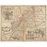
![Gloucestershire. Saxton (C. & Hole G.), Glocestriae Comitatus olim sedes Dobunorum, [1610]](https://portal-images.azureedge.net/auctions-2023/srdom10213/images/e3fd115e-b4b8-4b0b-a121-afcf00c98dc7.jpg?w=155&h=155)
* Gloucestershire. Saxton (C. & Hole G.), Glocestriae Comitatus olim sedes Dobunorum, [1610], hand-coloured engraved map, large strapwork cartouch...
Gloucestershire. Saxton (Christopher & Lea Philip), Glocester-Shire Described by C. S. Corrected and Amended with many Additions by P. Lea, circa ...

Gloucestershire. Speed (John), Glocestershire contrived..., Thomas Bassett & Richard Chiswell 1676
* Gloucestershire. Speed (John), Glocestershire contrived..., Thomas Bassett & Richard Chiswell 1676, hand-coloured engraved map, inset town plans...

Jamieson (Alexander). A Celestial Atlas Comprising a Systematic Display of the Heavens in a Series of Thirty Maps Illustrated by Scientific Descri...

Leicestershire. Darton (William & Dix Thomas). Leicestershire Divided into Hundreds..., circa 1819
Leicestershire. Darton (William & Dix Thomas). Leicestershire Divided into Hundreds and the Parliamentary Divisions, William Darton & Son, circa 1...

London Underground. Beck (H. C.). Map of London's Underground Railways, (750M 1-33), 1st edition, Waterlow & Sons Ltd. London, Dunstable & Watford...
![London. Lewis (Samuel). [Atlas to the Topographical Dictionary of England] circa 1844](https://portal-images.azureedge.net/auctions-2023/srdom10213/images/544af73b-4e4a-43d0-a004-afcf00c99168.jpg?w=155&h=155)
London. Lewis (Samuel). [Atlas to the Topographical Dictionary of England] circa 1844, lacking title and preliminaries, uncoloured folding engrave...

London. Tirion (Isaak), Kaart van Londen Enz. en van het Naby Gelegen Land..., Amsterdam, 1754, hand-coloured engraved map and based on J. Roque's...

Malay Peninsula. Rossi (Giacomo Giovanni), Penisola dell India di la dal Gange..., Rome, circa 1683, engraved map with contemporary outline colour...
![Malta. Blaeu (Johannes), Melite Insula, vulgo Malta, Amsterdam, circa 1662 - [67]](https://portal-images.azureedge.net/auctions-2023/srdom10213/images/199c9853-71a6-46cd-be17-afcf00c99318.jpg?w=155&h=155)
Malta. Blaeu (Johannes), Melite Insula, vulgo Malta, Amsterdam, circa 1662 - [67], engraved map with contemporary hand colouring, some overall ton...
Maps. Saxton (Christopher & Hole G.), Glocestriae comitatus olim sedes Dobunorum [1627], hand-coloured engraved map, large strapwork cartouche, mi...
![Middlesex. Speed (John), Midle-sex described..., Thomas Bassett & Richard Chiswell, [1676]](https://portal-images.azureedge.net/auctions-2023/srdom10213/images/a98d725d-7d84-4894-bfe4-afcf00c993c0.jpg?w=155&h=155)
* Middlesex. Speed (John), Midle-sex described with the most famous Cities London and Westminster, Thomas Bassett & Richard Chiswell, [1676], hand...
![Monmouth. Speed (John). The Countye of Monmouth..., Thomas Bassett & Richard Chiswell [1676]](https://portal-images.azureedge.net/auctions-2023/srdom10213/images/f8805816-77f9-4625-82a6-afcf00c9947b.jpg?w=155&h=155)
Monmouth. Speed (John). The Countye of Monmouth..., Thomas Bassett & Richard Chiswell [1676]
* Monmouth. Speed (John). The Countye of Monmouth with the situation of the Shire-towne Described, Thomas Bassett & Richard Chiswell [1676], hand-...

Norfolk. Speed (John), Norfolk A Countie Florishing & Populous Described and Devided with the Armes of such Noble Familes as have borne the Titles...

North Africa. Fries (Lorenz), Tabula IIII Affri, 1st edition, J. Gruninger, Strasbourg, 1522, woodblock map with early but crude hand colouring, t...

Northern Pacific Ocean. Zatta (Antonio), Nuove Scoperte de' Russi al Nord del Mare del Sud si nell' Asia, che nell' America, Venice 1776, engraved...
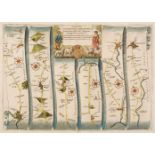
Ogilby (John). The Road from Glocester to Coventry, The Continuation of the Road from London to Holy head, The Road from London to Flambourough He...
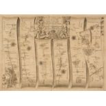
Ogilby (John). The Road from London to Aberistwith on the Sea Coast com. Cardigan, 1676 or later
Ogilby (John). The Road from London to Aberistwith on the Sea Coast com. Cardigan, The Continuation of ye Road from London to Aberistwith Plate ye...
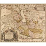
* Persia. Homann (Johann Baptist), Imperii Persici in omnes suas Provincias..., Nuremberg, circa 1720, engraved map with contemporary outline colo...
Persia. Homann (Johann Baptist), Imperii Persici in Omnes suas Provincias..., Nuremberg, circa 1720
* Persia. Homann (Johann Baptist), Imperii Persici in Omnes suas Provincias..., Nuremberg, circa 1720, engraved map with contemporary outline colo...

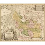
* Persia. Seutter (Matthaus), Opulentissimi Regni Persiae juxta suas Provinicias, circa 1730, engraved map with contemporary outline colouring, la...

Poland. A collection of 20 town and city plans, mostly 18th century, engraved city and town plans including Gdansk, Krakow, Wisloujscie, Wasosz, M...

Scotland. Bartholomew (John), Black's New Large Map of Scotland compiled from the Ordnance, Admiralty & other Surveys, A & C Black, 1862, twelve c...

Spain. Bouche (Jean Nicolas), Carte de l'Espagne Dressee par Guillaume Delisle..., Paris, 1789
* Spain. Bouche (Jean Nicolas), Carte de l'Espagne Dressee par Guillaume Delisle sur la Description de Rodrigo Mendez Sylva..., J. A. Dezauche, Pa...

Speed (John). Suffolk, Suffolke Described and Divided into Hundreds..., 1st edition, circa 1611
Speed (John). Suffolk, Suffolke Described and Divided into Hundreds, The Situation of the fayre towne Ipswich shewed, with the Armes of the most n...

Surrey. Bowen (Emanuel & Kitchin Thomas), Bowles's New Medium Map of Surrey, Divided into its Hundreds..., 1785, engraved map with contemporary wa...

Sydney. Robinson (H. E. C.), Robinson's Aeroplane Map of Sydney, published Sydney, circa 1910
Sydney. Robinson (H. E. C.), Robinson's Aeroplane Map of Sydney, published Sydney, circa 1910, colour lithographic map, old folds, some splits alo...

Thomson (John & Co.). A collection of nine maps, West India Islands, West Indies, Remote British Islands, Martinico & Dominica (on one sheet), Jam...

Vietnam. Tavernier (Jean-Baptiste), Carte Faite sur les Lieux..., au Tonquin, Paris circa 1679
Vietnam. Tavernier (Jean-Baptiste). Carte Faite sur les Lieux par Daniel Tavernier en Plusieurs Voiages quil a fait au Tonquin, Gervais Clouzier, ...

Wales. Jansson (Jan), Principatus Walliae pars Borealis vulgo North Wales, Amsterdam circa 1650
Wales. Jansson (Jan), Principatus Walliae pars Borealis vulgo North Wales, Amsterdam circa 1650, engraved map with contemporary outline colouring,...

Wales. Saxton (Christopher & Lea Philip), Radnor, Breknoke, Cardigan and Carmarthen..., 1693
Wales. Saxton (Christopher & Lea Philip), Radnor, Breknoke, Cardigan and Carmarthen, Discribed by C. S. Corrected and Amended with many Additions ...
![Wales. Speed (John), Four county maps, [1627 or later]](https://portal-images.azureedge.net/auctions-2023/srdom10213/images/677d19b0-526e-47af-b668-afcf00c9a0b1.jpg?w=155&h=155)
Wales. Speed (John), Merionethshire Described, George Humble, circa 1627, Montgomeryshire, Thomas Bassett & Richard Chiswell, circa 1676, The Coun...