
Refine your search
Estimate
Category
- Oil, Acrylic paintings & Mixed Media (74)
- Watercolours (64)
- Books, Manuscripts & Periodicals (62)
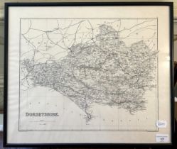
- Maps (36)
- Prints & Multiples (31)
- Drawings & Pastels (21)
- Furniture (18)
- Art Nouveau & Art Deco (17)
- Coins (13)
- Ceramics (12)
- Collectables (10)
- Porcelain (10)
- Classic Cars, Motorcycles & Automobilia (3)
- Entertainment Memorabilia (3)
- Metalware (3)
- Glassware (2)
- Photographs (2)
- Sculpture (2)
- Silver & Silver-plated items (2)
- Chinese Works of Art (1)
- Islamic Works of Art (1)
- Lighting (1)
- Salvage & Architectural Antiques (1)
- Sporting Memorabilia & Equipment (1)
- Vintage Fashion (1)
Creator / Brand
- English School (26)
- Lalique (10)
- Continental School (6)
- Royal Doulton (5)
- Ceramics Manufacturers / Genre (2)
- G Plan (2)
- John Cary (2)
- Moorcroft (2)
- Robert Morden (2)
- Wemyss Ware (2)
- Alexander Nasmyth (1)
- Bruno Mathsson (1)
- Dutch School (1)
- E H Shepard (1)
- Emanuel Bowen (1)
- Ercol (1)
- French School (1)
- Jan Jansson (1)
- John Rocque (1)
- John Seller (1)
- Ken Howard (1)
- Liberty (1)
- Majolica (1)
- Minton Hollins (1)
- Raleigh (1)
- Royal Lancastrian (1)
- Salvador Dali (1)
- Samuel Prout (1)
- Spode (1)
- Stanley Spencer (1)
- Thomas Bush Hardy (1)
- William Faden (1)
- William Heath Robinson (1)
- William Mudge (1)
- William Russell Flint (1)
Item Type
- Oil painting (61)
- Map (36)
- Book (34)
- Landscape (14)
- Landscape Painting (14)
- Vase (10)
- Mixed Media (9)
- Portrait (7)
- Atlas (6)
- Jug (6)
- Seating (6)
- 19th-21st Century Art (5)
- Chair (5)
- Table (5)
- Cartographers and Mapmakers (4)
- Ceramic Jug (4)
- Ceramic Vase (4)
- Furniture Makers (4)
- Modern & Impressionist Art (4)
- Road map (4)
- Abstract (3)
- Abstract Painting (3)
- Armchair (3)
- Bowl (3)
- Figure (3)
- Plate (3)
- Portrait Painting (3)
- Bible (2)
- Box (2)
- Dining Chair (2)
- Folio (2)
- Seat (2)
- Stool (2)
- Anglepoise (1)
- Bags & Handbags (1)
- Bibles (1)
- Bicycle (1)
- Cabinets & Case Pieces (1)
- Carving Knife (1)
- Ceramic Bowl (1)
- Ceramic Plate (1)
- Comic (1)
- Comics (1)
- Contemporary Art (1)
- Cup (1)
- Cutlery (1)
- Dictionary (1)
- Dining Table (1)
- Drypoint (1)
- Fork (1)
- Handbag (1)
- Jar (1)
- Lamp (1)
- Lamp Base (1)
- Letter (1)
- Mirror (1)
- Ordnance survey map (1)
- Plaque (1)
- Purse (1)
- Side Table (1)
- Sideboard (1)
- Sketchbook (1)
- Sport (1)
- Telephone (1)
- List
- Grid
A subscription to the Price Guide is required to view results for auctions ten days or older. Click here for more information
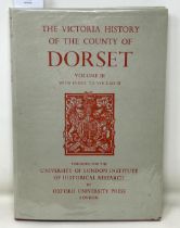

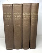
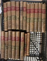
The Victoria History of the County of Dorset – A History of the County of Dorset – Volume Two,
The Victoria History of the County of Dorset – A History of the County of Dorset – Volume Two, edited by William Page, F. S. A., pub. Archibald Co...
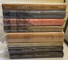
A complete set of The Royal Commission on Historical Monuments England – An Inventory of the Historical Monuments in Dorset, 8 volumes, each linen...
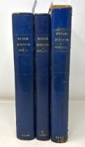
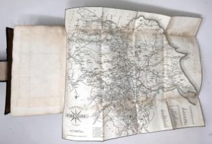
An Account of the Operations carried on for accomplishing A Trigonometrical Survey of England and
An Account of the Operations carried on for accomplishing A Trigonometrical Survey of England and Wales, first published in, and now revised from,...
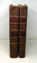
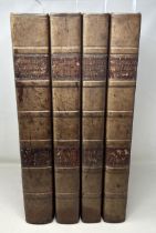
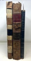
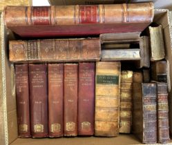
Hutchins History of Dorset, First edition, printed by W. Bowyer and J. Nichols, 1774, 2 vols, leather bound on board, original spines, newer board...
Hutchins History of Dorset Second edition, printed by John Nichols, Vol. 1 (1796), Vol. 2 (1803),
Hutchins History of Dorset Second edition, printed by John Nichols, Vol. 1 (1796), Vol. 2 (1803), Vol. 3 (1813), Vol. 4 (1815), leather bound on b...
Third edition, printed by John Bowyer Nichols, Vol. 1 (1861), Vol. 2 (1863), Vol. 3 (1868), Vol.
Third edition, printed by John Bowyer Nichols, Vol. 1 (1861), Vol. 2 (1863), Vol. 3 (1868), Vol. 4 (1870), bound in beige linen on board, some boa...
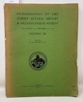
Proceedings of the DNHAS Vol. 68. Contains ‘The Plates in Hutchins’ History of Dorset’ by G. D.
Proceedings of the DNHAS Vol. 68. Contains ‘The Plates in Hutchins’ History of Dorset’ by G. D. Squibb – the only reliable way of checking presenc...
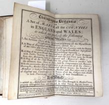
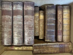
Thomas Badeslade & William Toms, Chorographia Britanniae or A Set of Maps of all the Counties of
Thomas Badeslade & William Toms, Chorographia Britanniae or A Set of Maps of all the Counties of England and Wales, 1742, a pocket atlasProvenance...
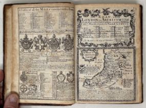
Cary’s Itinerary, 1817, by John Cary, half-bound in leather with marbled paper covers Provenance:
Cary’s Itinerary, 1817, by John Cary, half-bound in leather with marbled paper coversProvenance: From the collection of David Beaton, local histor...
John Owen & Emanuel Bowen, Britannia Depicta, 1720, first edition of a pocket road atlas that went
John Owen & Emanuel Bowen, Britannia Depicta, 1720, first edition of a pocket road atlas that went through many subsequent editionsProvenance: Fro...
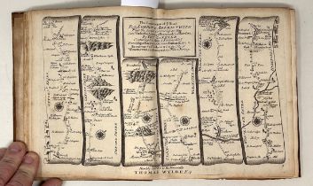
Thomas Gardner, A Pocket Guide to the English Traveller, 1719, the first pocket road atlas ever
Thomas Gardner, A Pocket Guide to the English Traveller, 1719, the first pocket road atlas ever published, 2 vols.Provenance: From the collection ...
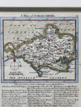
The Beauties of England and Wales – Dorsetshire, published James Cawthorn, London, 1803, quarter
The Beauties of England and Wales – Dorsetshire, published James Cawthorn, London, 1803, quarter bound leather and marbled paper on board, frontis...
Paterson’s Roads, 1822, bound in black linen on board, with marbled endpapers and marbled page
Paterson’s Roads, 1822, bound in black linen on board, with marbled endpapers and marbled page edges, including county maps from Cary’s Travellers...
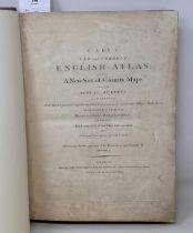
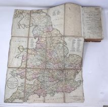
John Cary’s New & Correct English Atlas, 1787, an early example of accurate mapping, and a subscribers’ edition. Rebound in light brown leather wi...
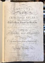
Charles Smith’s New English Atlas, 1804, the first county atlas to be based on the Meridian of
Charles Smith’s New English Atlas, 1804, the first county atlas to be based on the Meridian of Greenwich. A subscribers’ edition containing extens...
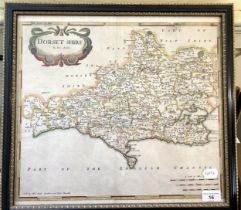
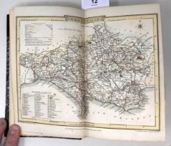
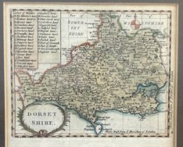
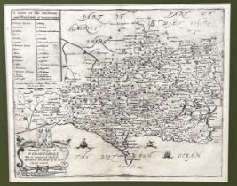
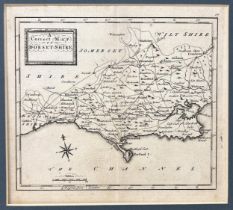
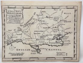
Robert Morden, 1695, Map of Dorset, first edition, from Camden’s Britannia (Stoke Wake printed
Robert Morden, 1695, Map of Dorset, first edition, from Camden’s Britannia (Stoke Wake printed twice, unique to first edition), 38 x 42 cmProvenan...
Frontispiece map from The Old Stone Crosses of Dorset, by Alfred Pope, 1906, 41 x 48 cmProvenance: From the collection of David Beaton, local hist...

Badeslade & Toms, map of Dorset 1742, 15.5 x 15.5 cm Provenance: From the collection of David
Badeslade & Toms, map of Dorset 1742, 15.5 x 15.5 cmProvenance: From the collection of David Beaton, local historian, retired academic and author ...
Francis Grose’s map, Dorset, printed from John Seller’s plate of 1695, 21.5 x 16 cm Provenance: From
Francis Grose’s map, Dorset, printed from John Seller’s plate of 1695, 21.5 x 16 cmProvenance: From the collection of David Beaton, local historia...
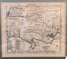
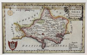
Emmanuel Bowen, map of Dorset, from Arts & Sciences, issued from 1759 – 1763, 19 x 22 cm Provenance:
Emmanuel Bowen, map of Dorset, from Arts & Sciences, issued from 1759 – 1763, 19 x 22 cmProvenance: From the collection of David Beaton, local his...
John Rocque, map of Dorset, from Small British Atlas, probably 1753, but maybe from a later edition 1762, 1764 or 1769, 17 x 20 cmProvenance: From...
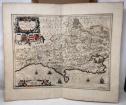
Jan Jansson, map of Dorset, 1650, 49.5 x 58 cm Provenance: From the collection of David Beaton,
Jan Jansson, map of Dorset, 1650, 49.5 x 58 cmProvenance: From the collection of David Beaton, local historian, retired academic and author of Dor...
Richard Blome, map of Dorset, 1671, 26 x 33 cm Provenance: From the collection of David Beaton,
Richard Blome, map of Dorset, 1671, 26 x 33 cmProvenance: From the collection of David Beaton, local historian, retired academic and author of Dor...
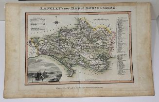
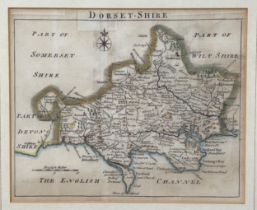
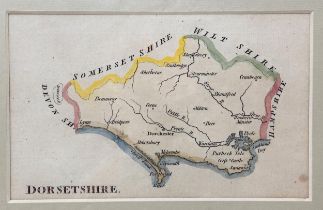
Langley & Belch, map of Dorset, 1817, 20 x 28 cm Provenance: From the collection of David Beaton,
Langley & Belch, map of Dorset, 1817, 20 x 28 cmProvenance: From the collection of David Beaton, local historian, retired academic and author of D...
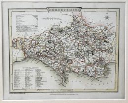
Map of Dorset, J Roper engraver, pub. Vernor & Hood 1805, frontispiece map in Beauties of England & Wales, 20 x 25 cmProvenance: From the collecti...
John Aiken, map of Dorset, 1800, 10 x 6 cm Provenance: From the collection of David Beaton, local
John Aiken, map of Dorset, 1800, 10 x 6 cmProvenance: From the collection of David Beaton, local historian, retired academic and author of Dorset ...
Kitchin & Jeffreys, map of Dorset, 1780, 20 x 15 cm Provenance: From the collection of David Beaton,
Kitchin & Jeffreys, map of Dorset, 1780, 20 x 15 cmProvenance: From the collection of David Beaton, local historian, retired academic and author o...
Thomas & John Osborne, map of Dorset, 1748, 16.5 x 18.5 cm Provenance: From the collection of
Thomas & John Osborne, map of Dorset, 1748, 16.5 x 18.5 cmProvenance: From the collection of David Beaton, local historian, retired academic and a...
Thomas Conder, map of Dorset, 1784, 11 x 17.5 cm Provenance: From the collection of David Beaton,
Thomas Conder, map of Dorset, 1784, 11 x 17.5 cmProvenance: From the collection of David Beaton, local historian, retired academic and author of D...
John Cowley, map of Dorset, 1744, 15 x 19 cm Provenance: From the collection of David Beaton,
John Cowley, map of Dorset, 1744, 15 x 19 cmProvenance: From the collection of David Beaton, local historian, retired academic and author of Dorse...
Pope (Alfred), The Old Stone Crosses of Dorset, complete with frontispiece map showing the locations
Pope (Alfred), The Old Stone Crosses of Dorset, complete with frontispiece map showing the locations of the crosses, Chiswick Press, 1903, 1st edi...
Treves (Sir Frederick), Highways and Byways in Dorset, Macmillan, 1906, 1st ed. bound green linen on
Treves (Sir Frederick), Highways and Byways in Dorset, Macmillan, 1906, 1st ed. bound green linen on board, and assorted books on DorsetProvenance...
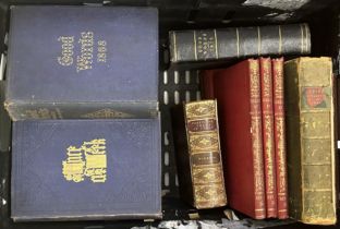
Good (Ronald), The Old Roads of Dorset, Horace G. Commin Ltd., 1966, and assorted books on Dorset
Good (Ronald), The Old Roads of Dorset, Horace G. Commin Ltd., 1966, and assorted books on DorsetProvenance: From the collection of David Beaton, ...
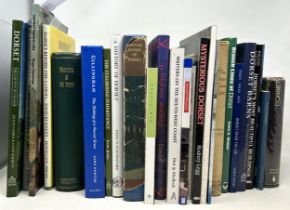
Memorials of Old Dorset Ed. Thomas Perkins & Herbert Pentin, Bemrose & Sons Ltd, 1907, 1st edition
Memorials of Old Dorset Ed. Thomas Perkins & Herbert Pentin, Bemrose & Sons Ltd, 1907, 1st edition bound linen on board, and assorted books on Dor...
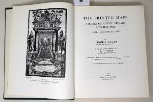
Chubb (Thomas), The Printed Maps in the Atlases of Great Britain and Ireland 1579 – 1870, Dawsons of
Chubb (Thomas), The Printed Maps in the Atlases of Great Britain and Ireland 1579 – 1870, Dawsons of Pall Mall 1974, 1st edition, bound in green l...
Catalogue of Maps in the Essex Record Office 1566 – 1837 Essex County Council 1947, 1st edition,
Catalogue of Maps in the Essex Record Office 1566 – 1837 Essex County Council 1947, 1st edition, bound in green linen on board and assorted books ...
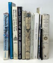
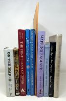
Tooley (R.V), Maps and Map-Makers, Batsford, fourth impression, 1962, bound in orange linen on
Tooley (R.V), Maps and Map-Makers, Batsford, fourth impression, 1962, bound in orange linen on board, and assorted books on cartographyProvenance:...
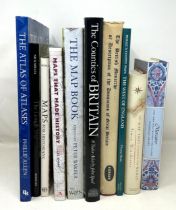
Smart (L), Maps That Made History, National Archives Kew 2004, 1st edition, bound in blue linen on
Smart (L), Maps That Made History, National Archives Kew 2004, 1st edition, bound in blue linen on board, and assorted books on cartographyProvena...
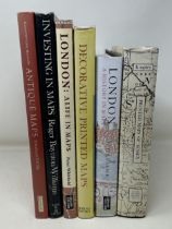
Skelton (R A), Decorative Printed Maps of the 15th to 18th Centuries, Spring Books 1967, 3rd impression, bound in blue linen on board, and assorte...
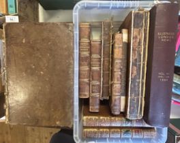
The Connoisseur, Vol II only, published 1793, The Adventurer, Vol IV only, published 1794, and The
The Connoisseur, Vol II only, published 1793, The Adventurer, Vol IV only, published 1794, and The Waverley Novels, 17 vols., half calf (box)Overa...
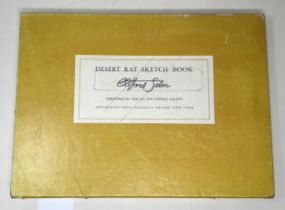
Saber (Clifford), Desert Rat Sketch Book, The African Campaign 1942-43, with box cover
The Gentlewoman,1893, binding poor, La Mode Illustree, 1874, some pages torn and creased, and A
The Gentlewoman,1893, binding poor, La Mode Illustree, 1874, some pages torn and creased, and A Rainha Da Moda, 1902, binding poor (3)
Assorted books, including Hall (S C), Ireland - Its Scenery, Character & Co (box)
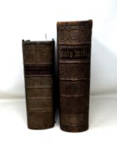
The Holy Bible (Baskerville), 1788, brushed calf, some repairs, later spine, and The Self Interpreting Family Bible, gilt tooled leather with bras...
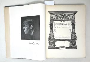
Beardsley (Aubrey), Early Work, and another volume, Later Work, bindings poor (2)
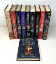
Pratchett (Terry), The Amazing Maurice, 2002, and nine other Pratchett books (10)

Pratchett (Terry), I Shall Wear Midnight, 2010 and nine other Pratchett books (10)
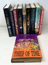
Pratchett (Terry), Thief of Time, 2001, and nine other Pratchett books (10)
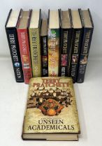
Pratchett (Terry), Unseen Academicals, 2009, and eight other Pratchett books (9)
Pratchett (Terry), Making Money, 2007, price clipped, with money, and seven other Pratchett books (
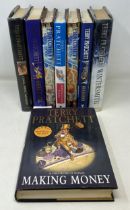
Pratchett (Terry), Making Money, 2007, price clipped, with money, and seven other Pratchett books (8)
Dante, The Vision of Purgatory and Paradise, illus. by Gustave Dore, half calf, and other assorted
Dante, The Vision of Purgatory and Paradise, illus. by Gustave Dore, half calf, and other assorted leather bindings (box)Sold with all faults, not...
Bailey (Nathan), Ovid's Metamorphoses, 3rd edition, 1791, calf, Conti (Natale), Mythology, Geneva
Bailey (Nathan), Ovid's Metamorphoses, 3rd edition, 1791, calf, Conti (Natale), Mythology, Geneva 1636, calf, and other assorted bindings (box)Sol...
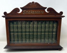
The Works of William Shakspeare, 12 vols., in a mahogany and glazed case, 32 cm wide lacks two bun
The Works of William Shakspeare, 12 vols., in a mahogany and glazed case, 32 cm widelacks two bun feet to base
Landais (Napoleon), Dictionnaire Francais, 1836, 2 vols., diced calf, Veronensis (Hieronymi de
Landais (Napoleon), Dictionnaire Francais, 1836, 2 vols., diced calf, Veronensis (Hieronymi de Prato) Sulpicii Severi, 1791, 2 vols., calf, and ot...
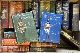
A collection of George Arthur Henty books, all with pictorial cloth bindings, including In The Irish
A collection of George Arthur Henty books, all with pictorial cloth bindings, including In The Irish Brigade and Sturdy and Strong (box)Title:YARN...
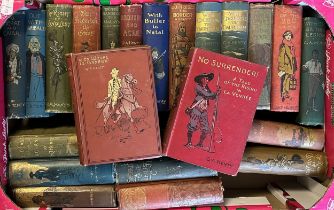
A collection of George Arthur Henty books, all with pictorial cloth bindings, including No Surrender
A collection of George Arthur Henty books, all with pictorial cloth bindings, including No Surrender and With Wolfe In Canada (box)Title:IN THE RE...
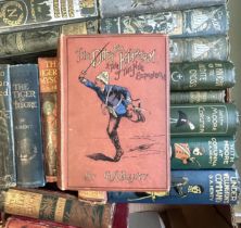
A collection of George Arthur Henty books, all with pictorial cloth bindings, including Under
A collection of George Arthur Henty books, all with pictorial cloth bindings, including Under Wellington's Command and The Dash For Khartoum (box)...
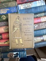
A collection of George Arthur Henty books, all with pictorial cloth bindings, including Beric The
A collection of George Arthur Henty books, all with pictorial cloth bindings, including Beric The Briton, and By England's Aid (box)Title:WON BY T...

Assorted fine art, reference and other books, including Wedgwood, Chelsea, Spode, Art Glass Nouveau,
Assorted fine art, reference and other books, including Wedgwood, Chelsea, Spode, Art Glass Nouveau, and China (4 boxes)
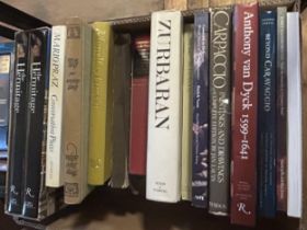
Assorted fine art reference books, including Anthony Van Dyck, Velazquez, and Early Dutch Painting (5 boxes)