Refine your search
Filtered by:
- Sale Section
4 items
- List
- Grid
This auctioneer has chosen to not publish their results. Please contact them directly for any enquiries.
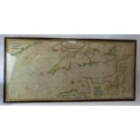

Lot 24
Map: A new hydrographical survey of The British Channel, after Thomas Jeffrey, printed for Sayer &
24Map: A new hydrographical survey of The British Channel, after Thomas Jeffrey, printed for Sayer &
Map: A new hydrographical survey of The British Channel, after Thomas Jeffrey, printed for Sayer & Bennett 1781. Framed and glazed. 160cm x 76cm.C...
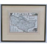
Lot 55
An 18th century framed map of Kent by Herman Moll c1724. Hand tinted engraving map size 31.5cm x
An 18th century framed map of Kent by Herman Moll c1724. Hand tinted engraving map size 31.5cm x 22cm. Frame 49cm x 41cm.Condition report: No dama...

A 17th century map of Huntingdon by John Speed, engraved by Jodocus Hondius dated 1662. Hand coloured engraving with centre fold, framed and glaze...

Lot 148
A large vintage German school map, circa 1920 depicting Europe over the centuries. Printed by
A large vintage German school map, circa 1920 depicting Europe over the centuries. Printed by Flemings Verlag Hamburg. Mounted on wooden poles. 1...