Filtered by:
- Category
- List
- Grid
This auctioneer has chosen to not publish their results. Please contact them directly for any enquiries.
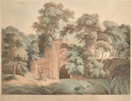

After Thomas Daniell (1749-1840) British. "Ruins at the Antient City of Gour formerly on the Banks
After Thomas Daniell (1749-1840) British. "Ruins at the Antient City of Gour formerly on the Banks of the River Ganges", Engraving, Plate No.4, 17...
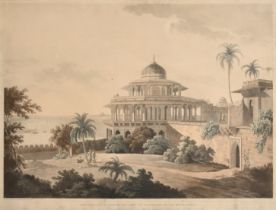
After Thomas Daniell (1749-1840) British. "The Chalees Satoon, in the Fort of Allahabad, on the
After Thomas Daniell (1749-1840) British. "The Chalees Satoon, in the Fort of Allahabad, on the River Jumna", Engraving, Plate No.V1, 17" x 23.5" ...
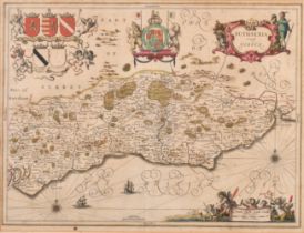
Jan Janszoon Jansson (1588-1664) Dutch. "Suthsexia vernacule Sussex", after Willem Janszoon Blaeu (
Jan Janszoon Jansson (1588-1664) Dutch. "Suthsexia vernacule Sussex", after Willem Janszoon Blaeu (1571-1638) Dutch, Hand coloured map, 15" x 20" ...
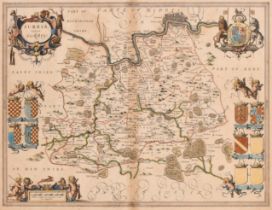
Jan Janszoon Jansson (1588-1664) Dutch. "Surria vernacule Surrey", Hand coloured map, 15" x 19.5" (
Jan Janszoon Jansson (1588-1664) Dutch. "Surria vernacule Surrey", Hand coloured map, 15" x 19.5" (38.1 x 49.5cm). Provenance: Julia Holmes, Hamps...
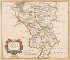
Robert Morden (1650-1703) British. "Darby Shire", Hand coloured map, 14" x 16.5" (35.5 x 41.9cm) and
Robert Morden (1650-1703) British. "Darby Shire", Hand coloured map, 14" x 16.5" (35.5 x 41.9cm) and seven others by the same hand, "Leicester Shi...
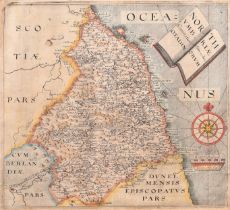
Christopher Saxton (1540-1610) British and William Hole (fl.1607-1624) British. "North Vmbriae",
Christopher Saxton (1540-1610) British and William Hole (fl.1607-1624) British. "North Vmbriae", Hand coloured map, Mounted, unframed 11" x 12" (2...
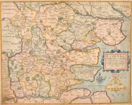
Christopher Saxton (1540-1610) British. "Essexia Comitatvs Qvem", Hand coloured map, Mounted,
Christopher Saxton (1540-1610) British. "Essexia Comitatvs Qvem", Hand coloured map, Mounted, unframed 11.75" x 14.5" (29.8 x 36.8cm) and another ...
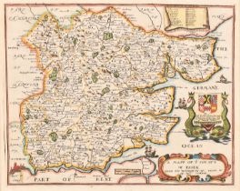
Richard Blome (1635-1705) British. "A Mapp of Ye County of Essex", Hand coloured map, Mounted,
Richard Blome (1635-1705) British. "A Mapp of Ye County of Essex", Hand coloured map, Mounted, unframed 10" x 12.5" (25.4 x 31.7cm). Provenance: J...
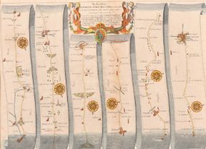
John Ogilby (1600-1676) British. "The Road from London to Chichester", Hand coloured map, Mounted,
John Ogilby (1600-1676) British. "The Road from London to Chichester", Hand coloured map, Mounted, unframed 12.5" x 17.25" (31.7 x 43.8cm) and ano...
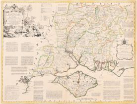
Emanuel Bowen (1694-1767) British and Thomas Kitchin (1718-1784) British. "Hampshire divided into
Emanuel Bowen (1694-1767) British and Thomas Kitchin (1718-1784) British. "Hampshire divided into its Hundreds", Hand coloured map, Mounted, unfra...
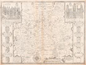
After John Speed (1552-1629) British. "Surrey, described and divided into Hundreds", Map, Mounted,
After John Speed (1552-1629) British. "Surrey, described and divided into Hundreds", Map, Mounted, unframed 15" x 20.25" (38.1 x 51.4cm). Provenan...
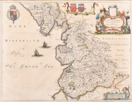
Joan Blaeu (1596-1673) Dutch. "Lancastria, Palatinatus, Lancaster et Lancas Shire", Hand coloured
Joan Blaeu (1596-1673) Dutch. "Lancastria, Palatinatus, Lancaster et Lancas Shire", Hand coloured map, Mounted, unframed, 15.5" x 19.75" (39.3 x 5...