Refine your search
Sale Section
Remove filter- Library Auction Maps & Atlases (5)
Estimate
Category
Creator / Brand
Item Type
Filtered by:
- Sale Section
- List
- Grid
A subscription to the Price Guide is required to view results for auctions ten days or older. Click here for more information
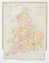

British Isles. 35 dissected, linen-backed, colour maps in green cloth covers numbered in gilt, 1-
British Isles. 35 dissected, linen-backed, colour maps in green cloth covers numbered in gilt, 1-37 [but lacking Nos. 19 & 28], plus reference key...
![[Drayton, Michael]. Allegorical map of Staffordshire, engraved by William Hole for Poly-Olbion, c.](https://portal-images.azureedge.net/auctions-2023/hanson10613/images/777e1810-8aa7-4c7b-b2b9-b0cf011952a4.jpg?h=210)
[Drayton, Michael]. Allegorical map of Staffordshire, engraved by William Hole for Poly-Olbion, c.
[Drayton, Michael]. Allegorical map of Staffordshire, engraved by William Hole for Poly-Olbion, c. 1612 or later, hand-coloured engraving on laid/...
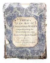
Smith, C. A New Map of England & Wales, hand-coloured copper engraving, dissected & linen-backed,
Smith, C. A New Map of England & Wales, hand-coloured copper engraving, dissected & linen-backed, London: C. Smith, 1804, 59.3 x 48cm, housed in w...
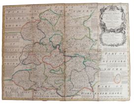
Bowen, Emanuel. Shropshire, c. 1760, hand-coloured, copper-engraved map on laid/chain-lined paper,
Bowen, Emanuel. Shropshire, c. 1760, hand-coloured, copper-engraved map on laid/chain-lined paper, dissected & linen-backed, housed in a marbled s...
The Harrow Atlas of Classical Geography, London: Edward Stanford, 1863. Small folio, 36cm, title
The Harrow Atlas of Classical Geography, London: Edward Stanford, 1863. Small folio, 36cm, title page & contents followed by 23 steel-engraved map...