Filtered by:
- Sale Section
- List
- Grid
A subscription to the Price Guide is required to view results for auctions ten days or older. Click here for more information

Africa. Blaeu (Willem Janszoon), Africae nova descriptio. auct: Guiljelmo Blaeuw. Amsterdam, circa 1650, uncoloured engraved carte-a-figure map, t...
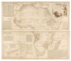
Africa. Laurie (Robert & Whittle James), Africa, with All Its States, Kingdoms, Republics, Regions, Islands, & ca. Improved and inlarged from D'An...
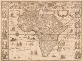
![Africa. Speed (John), Africae described, the manner of their Habits and Buildings..., [1676]](https://portal-images.azureedge.net/auctions-2023/srdom10227/images/b496d613-e19a-4d1e-ba26-b0af00bfef6a.jpg?h=210)
Africa. Speed (John), Africae described, the manner of their Habits and Buildings newly done into English, Thomas Bassett & Richard Chiswell [1676...
![Americas. Munster (Sebastian), Americae sive novi orbis..., [1588 - 1628]](https://portal-images.azureedge.net/auctions-2023/srdom10227/images/89fd678b-3302-49d9-bf2b-b0af00bfeff4.jpg?h=210)
Americas. Munster (Sebastian), Americae Sive Novi Orbis Nova Descriptio, Basle, [1588-1628], uncoloured woodblock map of North and South America, ...
Anglesey & Caernarvon. Saxton (Christopher), Mone Insulae modo Anglesey et Caernarvans duorum borialis Cambriae comitatuum olim vene do cia L. Gwy...
Barclay (Rev. James). The Universal English Dictionary..., John Tallis and Co. 1844, additional decorative half-title, frontispiece of a view of B...
Basire (James). A collection of 38 prospects of fortified towns and battle plans, originally published in Rapin de Thoyras's 'History of England',...
![Berkshire. Speed (John), Barkshire Described, John Sudbury & George Humble [1627]](https://portal-images.azureedge.net/auctions-2023/srdom10227/images/bcfcb981-2996-47e9-ae16-b0af00bff217.jpg?h=210)
Berkshire. Speed (John), Barkshire Described, John Sudbury & George Humble [1627], hand-coloured engraved map, the upper margin decorated with a p...
British County Maps. A collection of approximately 85 maps, 19th-century, engraved county maps, many with contemporary colouring, including exampl...
![British Isles. Gastaldi (Giacomo), Tabula Europae I, [1548]](https://portal-images.azureedge.net/auctions-2023/srdom10227/images/bbbeb242-94b7-40f6-942c-b0af00bff340.jpg?h=210)
British Isles. Gastaldi (Giacomo), Tabula Europae I, [1548], uncoloured engraved Ptolemaic map with decorative vignettes to vertical margins, some...
British Isles. A collection of approximately 100 maps, mostly 19th & early 20th century, engraved, lithographic and photolithographic maps of the ...
British Isles. A Collection of approximately 200 Maps, mostly 19th & early 20th century, engraved, lithographic and photolithographic maps of Brit...
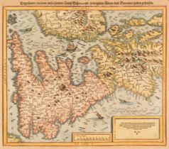
British Isles. Munster (Sebastian), Engellandt mit dem anstossenden Reich Schottlandt so vor zeiten Albion und Britannia haben geheissen, Basel: S...
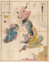
British Isles. Phillips, (John), Geological Map of the British Isles, and Adjacent Coast of France 1862, Society for Promoting Christian Knowlege,...

British Isles. Walker (J. & C.). Map of the British Isles Showing the Cities, Borough & Market Towns, The Principal Villages, Railways, Mail & Tur...
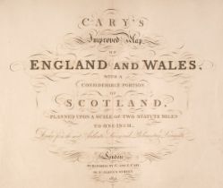
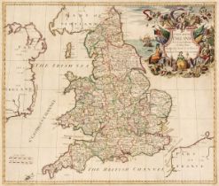
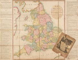
Cary (G. & J.). Cary's Improved Map of England and Wales with a considerable portion of Scotland, planned upon a scale of two statute miles to one...
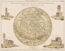
Celestial Maps. Zatta (Antonio), Planisferio Celeste Settentrionale Taagliato sull: Equatore & Planisferio Celeste Meridionale Tagliato sull: Equa...
![De Vaugondy (Robert). Carte des Grandes Routes D'Angleterre, D'Ecosse et D'Irlande [1757 - 68],](https://portal-images.azureedge.net/auctions-2023/srdom10227/images/5259ad0f-468b-4833-a325-b0af00bff758.jpg?h=210)
De Vaugondy (Robert). Carte des Grandes Routes D'Angleterre, D'Ecosse et D'Irlande [1757 - 68],
De Vaugondy (Robert). Carte des Grandes Routes D'Angleterre, D'Ecosse et D'Irlande [1757 - 68], engraved map with contemporary hand-colouring, lar...
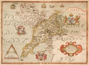
![Denbigh Shire. Speed (John), Denbigh Shire, Thomas Bassett & Richard Chiswell [1676]](https://portal-images.azureedge.net/auctions-2023/srdom10227/images/2f1015b7-8b95-4c64-83e4-b0af00bff7e2.jpg?h=210)
* Denbigh Shire. Speed (John), Denbigh Shire, Thomas Bassett & Richard Chiswell [1676], hand-coloured engraved map, inset town plan of Denbigh, sl...
![Derbyshire. Speed (John), Anno Darbieshire described, Thomas Bassett & Richard Chiswell [1676]](https://portal-images.azureedge.net/auctions-2023/srdom10227/images/021dc8e6-de59-4663-8f19-b0af00bff864.jpg?h=210)
Derbyshire. Speed (John), Anno Darbieshire described, Thomas Bassett & Richard Chiswell [1676]
Derbyshire. Speed (John), Anno Darbieshire described, Thomas Bassett & Richard Chiswell [1676], hand-coloured engraved map, inset city plan of Der...
* Devon. A collection of 28 county maps, 17th - 19th century, engraved maps, including examples by or after Blome, Badeslade & Toms, Ramble, Bowen...
England & Wales. A collection of eleven maps, 17th & 18th century, hand-coloured engraved maps, including examples by or after Schenk, Coronelli, ...
![England & Wales. Hole (William), Britannia [1610]](https://portal-images.azureedge.net/auctions-2023/srdom10227/images/7c030a54-37f2-4fa3-ae64-b0af00bffa42.jpg?h=210)
England & Wales. Hole (William). Britannia [1610], uncoloured engraved map displayed in an oval cartouche with decorative margins, 265 x 165 mm, t...
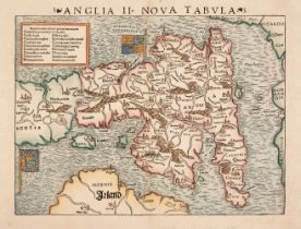
England & Wales. Munster (Sebastian), Anglia II. Nova Tabula, Basle, circa 1550, hand-coloured woodcut map, inset key with prominent place names, ...
England & Wales. Seaton (Robert), This New Map of England & Wales, Compiled from the latest Surveys, is Respectfully Dedicated to the Queen by Her...
England & Wales. Wallis's Tour Through England and Wales, A New Geographical Pastime, London: John Wallis, 24th December 1794, engraved map with c...
![Essex. Speed (John), Essex devided into Hundreds..., [1676]](https://portal-images.azureedge.net/auctions-2023/srdom10227/images/355f81c8-11aa-4c49-9b8b-b0af00bffca7.jpg?h=210)
* Essex. Speed (John), Essex devided into Hundreds, with the most antient and fayre Towne Colchester described and other memorable Monuments obser...
Europe. A collection of 19 maps, 17th - 19th-century, engraved maps of the continent, countries and regions, including examples by or after Senex,...
Foreign Maps. A collection of approximately 150 maps, 17th - 19th-century, engraved maps of countries, town & city plans and regions, including ex...
Foreign Maps. A collection of approximately 275 maps, mostly 19th & early 20th century, engraved, lithographic and photolithographic maps of count...
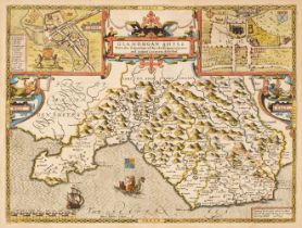
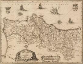
Glamorgan. Speed (John). Glamorgan Shyre with the sittuations of the Chiefe Towne Cardyff and ancient LLandaffe Described, John Sudbury & George H...
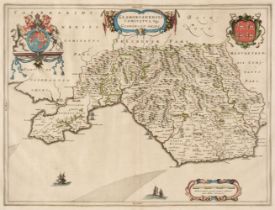
* Glamorganshire. Blaeu (Johannes), Glamorganensis comitatus vulgo Glamorgan Shire, circa 1648, engraved map with contemporary outline colouring, ...
![Hampshire. Speed (John), Hantshire described and devided, Thomas Bassett & Richard Chiswell, [1676],](https://portal-images.azureedge.net/auctions-2023/srdom10227/images/a2220a71-5efb-4462-bc5f-b0af00bfffd7.jpg?h=210)
Hampshire. Speed (John), Hantshire described and devided, Thomas Bassett & Richard Chiswell, [1676],
Hampshire. Speed (John), Hantshire described and devided, Thomas Bassett & Richard Chiswell, [1676], hand coloured engraved map, inset town plan o...
![Leicestershire. Speed (John), Leicester both Countye and Citie described..., [1627]](https://portal-images.azureedge.net/auctions-2023/srdom10227/images/59ea4aa8-b676-4812-a0db-b0af00c0006e.jpg?h=210)
Leicestershire. Speed (John), Leicester both Countye and Citie described, The Honorable Famylies that have held the titles of Earls thereof, with ...
![Leicestershire. Speed (John), Leicester both Countye and Citie Described..., [1627]](https://portal-images.azureedge.net/auctions-2023/srdom10227/images/f367da1e-4d54-4a2c-92fd-b0af00c0010d.jpg?h=210)
Leicestershire. Speed (John), Leicester both Countye and Citie Described, The Honorable Famylies that have had the titles of Earls thereof. With o...
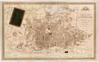
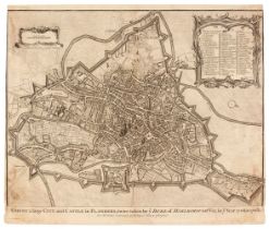
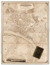
Liverpool. Gage (Michael Alexander), This Trigonometrical Plan of the Town and Port of Liverpool including the environs of Kirkdale Everton Lowhil...
London & The River Thames. A collection of 22 folding maps, 19th & early 20th century, folding engraved, lithographic and photomechanical maps, in...
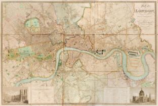
London. Greenwood (C & J), Map of London from an actual survey made in the years 1824, 1825 & 1826..., Extended and Comprising the various improve...
![Middlesex. Speed (John). Midle-Sex described..., George Humble [1611 - 27]](https://portal-images.azureedge.net/auctions-2023/srdom10227/images/d7801428-1f0c-4369-af2e-b0af00c0035f.jpg?h=210)
* Middlesex. Speed (John), Midle-Sex described with the most famous Cities of London and Westminster, George Humble [1611 - 27], engraved map with...
Newcastle Upon Tyne. Oliver (Thomas), Plan of the Town & County of Newcastle Upon Tyne and the Borough of Gateshead with their respective Suburbs....
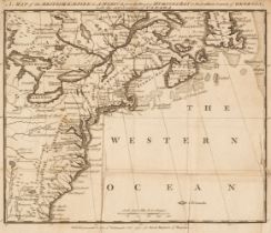
North America. A Map of the British Empire in America, from the Head of Hudson Bay to the Southern Bounds of Georgia, with the intervention of Can...
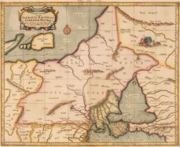
* Poland & Eastern Europe. A collection of 9 maps, 16th - 19th century, engraved regional maps, military maps, 'mythical creatures' and 'family tr...
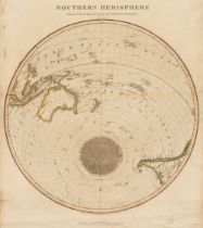
![Polar Regions. Thomson (J. publisher), Southern Hemisphere [and] Northern Hemisphere, 1820](https://portal-images.azureedge.net/auctions-2023/srdom10227/images/d571f531-4576-4fad-9cb5-b0af00c005a7.jpg?h=210)
Polar Regions. Thomson (J. publisher), Southern Hemisphere [and] Northern Hemisphere, circa 1820, a pair of maps engraved by Robert Kirkwood, both...
* Portugal. A collection of 25 maps, 17th - 19th century, engraved maps, including examples by or after Merian, Moll, Van der Aa, Morden, Crepy, K...
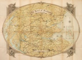
Scotland. Johnston (W. & A.K. printers), The Heart of Scotland, Gleneagles, constructed and printed by W. & A. K. Johnston Ltd. Edinburgh, publish...
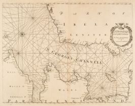
Sea Charts. Collins (Capt. Greenville), Untitled Chart of the Irish Sea, circa 1720, uncoloured chart, orientated to the east, slight staining, 45...
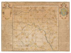
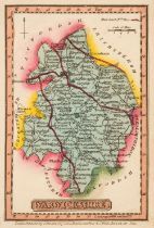
Shropshire. Porter (Benjamin), A New and Correct Map of Shrop-Shire with ye parts Adjacent Containing all ye County Towns, Market Towns & most Con...
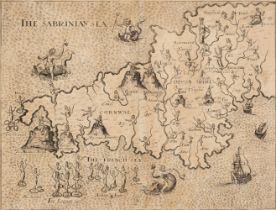
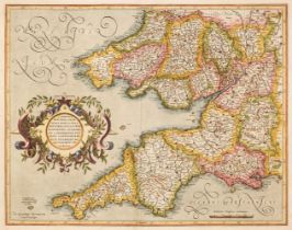
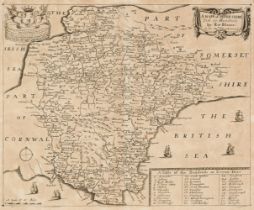
* South West England. Drayton (Michael), Untitled map of Devon and Cornwall, circa 1612, uncoloured engraved allegorical map of Devon and Cornwall...
![Speed (John). Title and Dedication pages, Thomas Bassett & Richard Chiswell [1676]](https://portal-images.azureedge.net/auctions-2023/srdom10227/images/944b101c-13ab-4117-a903-b0af00c008cd.jpg?h=210)
* Speed (John). Title and Dedication pages, Thomas Bassett & Richard Chiswell [1676], hand-coloured engraved title & dedication page, each approxi...
![Sussex. Saxton (Christopher & Kip William), Sussexia sive Southsex olim pars..., [1637]](https://portal-images.azureedge.net/auctions-2023/srdom10227/images/fa931291-6206-4d9a-b6c0-b0af00c00954.jpg?h=210)
* Sussex. Saxton (Christopher & Kip William), Sussexia sive Southsex olim pars Regnorum [1637], hand-coloured engraved map, re-margined on the ver...
Sydney. Guide to the Port of Sydney N. S. W. published by The Maritime Services Board of N. S. W. printed by D. H. Paisley, Govt. printer, circa ...
Teesdale (Henry, publisher). New British Atlas, Containing a Complete set of County Maps, on which are Delineated all the Principal Cross Roads, C...
Thomson (John). A New General Atlas, consisting of a series of geographical designs on various projections, exhibiting the form and component part...
![Wales. Speed (John), Six Welsh County Maps, Henry Overton, [1710 - 43]](https://portal-images.azureedge.net/auctions-2023/srdom10227/images/281191d8-21c0-46dd-8d20-b0af00c00b64.jpg?h=210)
* Wales. Speed (John), Six Welsh County Maps, Anglesey Antiently called Mona Described, Cardigan Shyre Described..., The Countie of Radnor Describ...
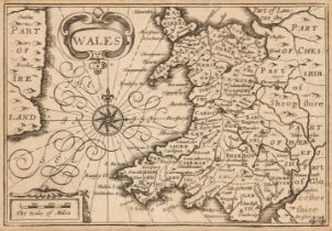
![Wales. Speed (John), Wales, Thomas Bassett & Richard Chiswell [1676]](https://portal-images.azureedge.net/auctions-2023/srdom10227/images/8507aa45-ca12-4e39-bbb0-b0af00c00bf8.jpg?h=210)
* Wales. Speed (John), Wales, Thomas Bassett & Richard Chiswell [1676], hand-coloured engraved map, twelve oval vignettes of principal cities to t...
* Wales. Van den Keere (Pieter), Eight maps of Wales and Welsh counties, comprising of, Wales, Glamorganshire, Pembrokshire (sic), Mounmouthshire ...
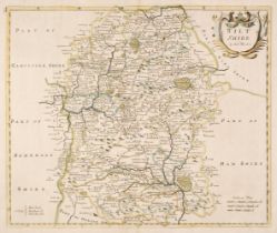
![Wiltshire. Speed (John), Wilshire, Thomas Bassett & Richard Chiswell [1676]](https://portal-images.azureedge.net/auctions-2023/srdom10227/images/5df6800f-9766-4b1b-aa27-b0af00c00d23.jpg?h=210)
Wiltshire. Speed (John), Wilshire, Thomas Bassett & Richard Chiswell [1676], uncoloured engraved map, inset city plan of Salisbury and an inset vi...
![Worcestershire. Speed (John), Worcestershire Described, J. Sudbury & G. Humble [1627]](https://portal-images.azureedge.net/auctions-2023/srdom10227/images/8814b8c6-2e76-411e-b408-b0af00c00dac.jpg?h=210)
Worcestershire. Speed (John), Worcestershire Described, John Sudbury & George Humble [1627], hand-coloured engraved map, an inset town plan of Wor...
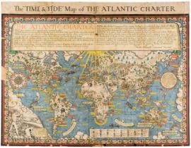
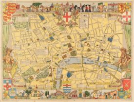
World. Gill (Macdonald). The "Time and Tide" Map of the Atlantic Charter, George Philip and Son Ltd, 1944, large colour photolithographic map, old...
![World. La Perouse (Jean Francois), Mappe Monde..., Paris [1797]](https://portal-images.azureedge.net/auctions-2023/srdom10227/images/b9294f91-e1f7-47fe-a4ea-b0af00c00f05.jpg?h=210)
World. Perouse (Jean Francois Galaup, Comte de la), Mappe Monde ou Carte Reduite des Parties Connues du Globe pour Servir au Voyage de la Perouse,...