Filtered by:
- Category
- List
- Grid
A subscription to the Price Guide is required to view results for auctions ten days or older. Click here for more information
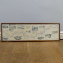

A contemporary Nigel Houldsworth "Fisherman's Map of Salmon Pools on the River Tweed'', together
A contemporary Nigel Houldsworth "Fisherman's Map of Salmon Pools on the River Tweed'', together with four signed Christopher Curtis humorous poem...
'A Geographical Companion throughout England & Wales including part of Scotland', engraved and
'A Geographical Companion throughout England & Wales including part of Scotland', engraved and published, Septr. 9th 1822 by G F Cruchley, section...
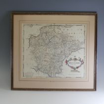
Robert Morden; A hand-coloured map of Devonshire, framed and glazed, the map approx. 43x36cm.
Robert Morden; A hand-coloured map of Devonshire, framed and glazed, the map approx. 43x36cm.
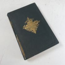
Gosse (Philip Henry); 'Actinologia Britannica, A History of The British Sea - Anemones and Corals,
Gosse (Philip Henry); 'Actinologia Britannica, A History of The British Sea - Anemones and Corals, pub. Van Voorst, London, 1860, publishers gilt ...
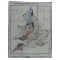
A 'Geological Map of England Wales, compiled from the latest documents. Shewing also the principle
A 'Geological Map of England Wales, compiled from the latest documents. Shewing also the principle roads, railways, rivers and canals.', by J. Gar...

Mudge (Lt. Col. William); Ordnance Geological Survey; thirteen maps relating to Devon, Cornwall
Mudge (Lt. Col. William); Ordnance Geological Survey; thirteen maps relating to Devon, Cornwall and Somerset, sheet no.'s 20, 21, 22, 23, 24, 25, ...
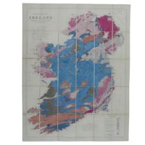
Joseph Beete Jukes; A linen backed Geological Map of Ireland, published by Edward Stanford, London, S.W and Hodges & Smith, Dublin, 1872, in publi...
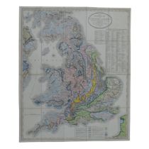
Geology; Smith (William) 'A New Geological Map of England and Wales with the Inland Navigations
Geology; Smith (William) 'A New Geological Map of England and Wales with the Inland Navigations exhibiting the Districts of Coal and other sites o...